I live on the edge of a place called El Parque de las Cañadas (The Trail Park). Which happens to be on a bay that gets 300+ days of sunny, warm riding weather, even in the middle of winter. As if that weren't enough, two new long distance trails now meet right in the middle of El Parque.
The nearby train station has easy access, so you can start making plans.
The image to the left shows the trailhead which is only about 600 meters from the train stain. Unfortunately the station is being rebuilt, so the instructions might be a bit tricky at first. When you get off the train keep the old town and the distant Atlantic behind you. The station has now been torn down. The temporary station is on the other side of the tracks, about 500 meters farther from the trailhead. Now all you have to do is turn right when you exit the station. Just follow the road parallel to the tracks and you will come to the trailhead. A pretty Mediterranean Pine forest should be visible not too far off in the distance ahead of you. Looking in this direction and standing on the inland side of the tracks (away from the town), turn right. You should be on a quiet road with sidewalks that runs along the railway to your right, and offers views of the pines off to the left. Soon you should come right up to the pines. A large information board with map marks the trailhead. Follow the dirt road that starts here. The pines should be on your left and the last group of houses to your right as the trail heads out across the fields.
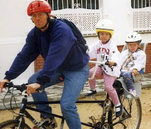
Bicycle Trips from Puerto Real - Trailhead (part 1)
Bicycle Trips from Puerto Real - Romans (part 2)
 As you head out of town, you will see large Roman oven across the field to your left. (The age and origin of the oven are debatable. There is a good chance that it is not Roman, and maybe not even an oven.) Continue straight ahead and pass under the highway. Coming out from under the bridge the trail marker presents two options. You can either go straight, which takes you up a hill. Or you can turn left on the dirt road that runs parallel to the highway. Both are interesting options as either of them will lead you deeper into El Parque de las Cañadas. In any case, the trails all interconnect with the network.
A NOTE ABOUT THE ROMANS: At this point, if you wander into the field to the left of the trail, you will be able to see a large deep pit with water at the bottom forming a pond. This is what remains of the large Roman quarry that produced clay for the oven in the photo above. This quarry used to be a lot bigger, in fact reaching the area near the oven.  The recent construction of the new bypass has since covered most of these historic scares carved into the land. When the new highway was being build, an enormous Roman mosaic was also unearthed just south of this area. That has apparently been transferred somewhere for safe keeping.
It is also interesting to note that the amphoras produced in the oven were taken (probably by ship) to a coastal settlement some 80 kilometers south of here. There they were filled with garum (from what I gather a sort of fish liver pate, highly prized by discerning Roman palates), and sent to Rome. The bike trail that is described here leads right up to the ruins of that Roman village, which produced garum. The path to the right is El Corredor Verde Dos Bahias (The Two Bay Greenway), a well marked trail that connects the Atlantic and the Mediterranean. It also overlaps a section of the TransAndalus route. The trail along the highway soon comes to another trail sign indicating the middle path of three options. There will soon be stables on the left, and you may see horses all over the fields around you. The large white buildings of the University Hospital Complex should be visible ahead .
Bicycle Trips from Puerto Real - Banana Farm (part 3)
 The image on the left shows the trail as it passes by the stables.
The day after I wrote the previous post, I pedaled through here, and I got to see this mare with her foal lying down right in the middle of the road. I got off my bike and tried to pass quietly, but I startled the colt, or filly, and all the horses ran off into the field. (Click on the image if you want to try to see the foal a little bit better.)
At this point, you are probably already about 4 km from the train station, but it seems like less because it's such a relaxing ride.
After going almost completely around the hospital complex (you have to cross the road twice - careful with traffic, especially ambulances and buses), you enter an extremely pretty and well marked section of the trail. This section follows an age old royal livestock track, which is over a hundred meters wide at most points. It offers a lot of shade, and you can usually discover pretty little goat tracks running parallel to the main marked trail.
Some 8 km out of town, at the second major trail
intersection, there is a group of signs and information boards. This area is just in front of a large vineyard. The signs indicate the direction of the main trail, but you can also turn left on the alternate trail - Corredor Verde Dos Bahias Trazado Alternativo. The main trail goes through some beautiful and quiet inland farm country. The first few kilometers are perfect, but as you continue, you may find that during the rainy periods it is flooded and covered with thick sticky mud. The trees also start to disappear, and it can get incredibly hot.
The alternate path to the left stays closer to the coast. It offers more shade, initially flatter riding and more places to stop and rest. This route also follows the TransAndalus, an unmarked (well, almost - look closely at the image on the left), yet well thought out and documented selection of trails that loop the entire perimeter of Andalucia for over 2000 km.
If you turn left at the signs by the vineyard, remnants of a short, but very pretty bike path visible in the photo on the right. The old bike path runs parallel along the right side of the more evident dirt road.you can also follow the You will soon come to a paved country road, which is the only access to the tiny rural community of La Chacona. This road has very little traffic. In any case it can be avoided completely by following a little goat track on the left side of the roadway. The image on the left shows the green houses that contain a  banana plantation, something not very common in this region. It is possible to take a dirt road right up the farm and buy some bananas. There is also a good possibility that the friendly farmer may offer a free tour of his unique installations. In the distance behind the green houses and pines, you can see huge windmills spinning slowly.
Bicycle Trips from Puerto Real - The New Bike Path (part 4)
The road from La Chacona comes to a historic intersection just past the banana trees. At the point where the main road curves sharply to the right, there are remnants of asphalt from two older roads. To the left all that remains now is a dirt road, but straight ahead the remaining bits of road surface have the appearance of having been turned into to a bike path. This illusion quickly disappears into a narrow path that gets very sandy at points. It runs right next to the main road which tends to have faster moving vehicules at this point. Shortly another thicker area of pine forest appears. This is yet another of the royal Spanish livestock trails. To the right the trail leads to the tiny village called "El Meadero de la Reina". This town is often cited as one of the places with the strangest names in all of Spain. It means - The Place Where the Queen Peed (the Spanish wording being a bit less euphemistic). It has a tiny country store which also serves as very basic venta (small country tavern).
Some hundred meters to the right is an even tinier country store. It it seems closed, just check at the house that is attached to it. The trail to the left is quite popular. It is the alternate route for the Corredor Verde Dos Bahias. The road that continues straight ahead has a newly built bike path running alongside it on the right (see photo). So new in fact that is pedestrian bridge over the stream is still unfinished. Here the quickest way to get by is on the main road. Care should be taken, as motor vehicle travel pretty fast here, and the bridge is not very wide.
After the bridge the bike path continues alongside the road. The open fields soon give way to rural homes and shortly afterwards the bath path ends. This neighborhood is called El Marquesado, and is the last chance for refreshment before heading out towards Chiclana.
Just before the bike path ends, the TransAndalus turns left. It follows the first dirt road on the left where the bike path enters El Marquesado. Soon the trail heads out into open farm country.